
Ficheru:The Man in the High Castle Plausible World Map.png
Tamañu d'esta previsualización: 800 × 579 pixels. Otres resoluciones: 320 × 232 pixels | 640 × 463 pixels | 1024 × 741 pixels | 1280 × 926 pixels | 1577 × 1141 pixels.
Ficheru orixinal (1577 × 1141 píxels, tamañu de ficheru: 400 kB, triba MIME: image/png)

|
This map, as well as other fictitious maps, is fictitious or too incorrect (i.e. due to anachronism) to be used in real-life contexts (contemporary or historic). It may have some visual elements that are similar to official maps such as colors or certain layout features, but they are NOT official and don't have any official recognition. |
[[Category:]]
Resume
| Descripción |
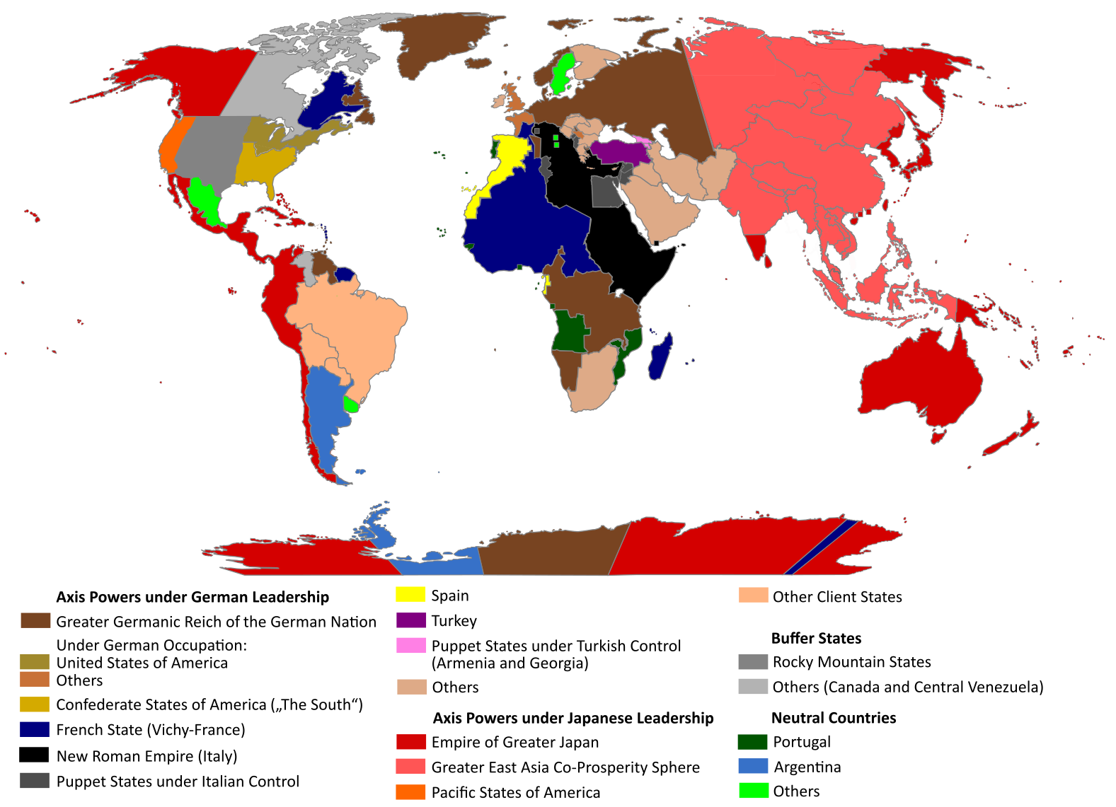
English: "The Man in the High Castle" is an alternate history novel by Philip K. Dick. It is set in a world in which the Axis powers have won World War II. This map is inspired by Dick's story and shows a plausible division of the world between Nazi Germany (dark brown), Imperial Japan (dark red) and their respective allies. However, the map is much more precise than the book describes.
https://web.archive.org/web/20191202005150/http://www.high-castle-world-map.com:80/ |
| Data | |
| Fonte | Trabayu propiu |
| Autor | RobintheHighCastle |
| Permisu (Cómo reutilizar esti ficheru) |
Llicencia
Yo, el titular de los drechos d'autor d'esta obra, la espublizo baxo la siguiente llicencia:
Este archivo está disponible bajo la licencia Creative Commons Attribution-Share Alike 4.0 International.
- Ye llibre:
- pa compartir – pa copiar, distribuir y comunicar públicamente la obra
- pa remezclar – p'adautar la obra
- Baxo les condiciones siguientes:
- reconocimientu – Tienes de dar el créitu apropiáu, apurrir un enllaz a la llicencia ya indicar si realizasti dalgún cambéu. Puedes faelo de cualquier mou razonable ,pero non de manera que suxera l'encontu del autor pa ti o pal usu que faigas.
- compartir igual – Si entemeces, tresformes o te bases nesti material, tienes de distribuir les tos contribuciones baxo la mesma llicencia o una compatible cola orixinal.
Historial del ficheru
Calca nuna fecha/hora pa ver el ficheru como taba daquella.
| Data/Hora | Miniatura | Dimensiones | Usuariu | Comentariu | |
|---|---|---|---|---|---|
| actual | 14:55 29 och 2021 | | 1577 × 1141 (400 kB) | Saltner67 | Added the portoguese colonies Cabinda and Ajuda since they would still have existed in this world. |
| 08:05 20 xun 2021 |  | 1613 × 1143 (417 kB) | Gernsback67 | Changed "Greater Asian Co-Prosperity Sphere" in "Greater East Asia Co-Prosperity Sphere", which is correct. | |
| 15:30 16 och 2020 |  | 1611 × 1138 (418 kB) | Saltner67 | Restored the latest version. Please do not revert any changes, which have been made to this file so far, without any communication with the author of the map. All changes made here have been initialized by the author and are a result of the same process which has led to the creation of the map in the first place. | |
| 08:25 16 och 2020 |  | 1621 × 1137 (392 kB) | Gooduserdude | RV Original research: this image is based on a source and should not be altered | |
| 14:15 29 mar 2020 |  | 1611 × 1138 (418 kB) | Saltner67 | Improved the accuracy of borders of Mongolia and Manchukuo. | |
| 15:58 27 mar 2020 |  | 1607 × 1138 (418 kB) | Saltner67 | Enlarged Manchukuo and added the puppet states of Yakutia and Krasnoyarsk/Irkutsk after more research on Kantokuen. | |
| 19:07 12 mar 2020 |  | 1612 × 1143 (411 kB) | Saltner67 | Moved the Swiss Canton of Valais from Germany to Italy, as has been prepared in the plans for Operation Tannenbaum. | |
| 18:57 8 feb 2020 |  | 1605 × 1139 (411 kB) | Saltner67 | Reinserted the territories of Tunisia,Greece, Crete and Cyprus after research on the Italian plannings and Greece in WWII. | |
| 13:21 21 pay 2019 |  | 1611 × 1133 (409 kB) | Gernsback67 | Enlarged Mongolia again after more research on pan-mongolism. | |
| 15:13 21 set 2019 |  | 1610 × 1137 (408 kB) | Saltner67 | unified Mongolia, enlarged Manchukuo and Thailand, re-inserted the real-life borders of Laos and Vietnam after research on Demchugdongrub, Kantokuen, Thailand and Indochina in WWII |
Usu del ficheru
Nun hai páxines qu'usen esti ficheru.