
Ficheru:Cold War Map 1959.svg

Tamañu de la vista previa PNG d'esti ficheru SVG: 800 × 406 pixels. Otres resoluciones: 320 × 162 pixels | 640 × 325 pixels | 1024 × 520 pixels | 1280 × 650 pixels | 2560 × 1299 pixels | 940 × 477 pixels.
Ficheru orixinal (ficheru SVG, 940 × 477 píxels nominales, tamañu de ficheru: 853 kB)
Resume
| Descripción |
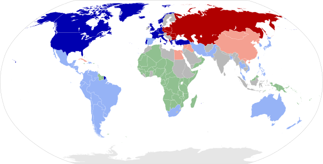
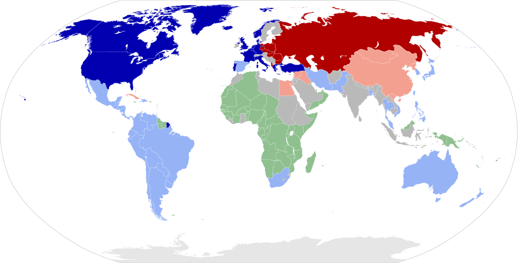
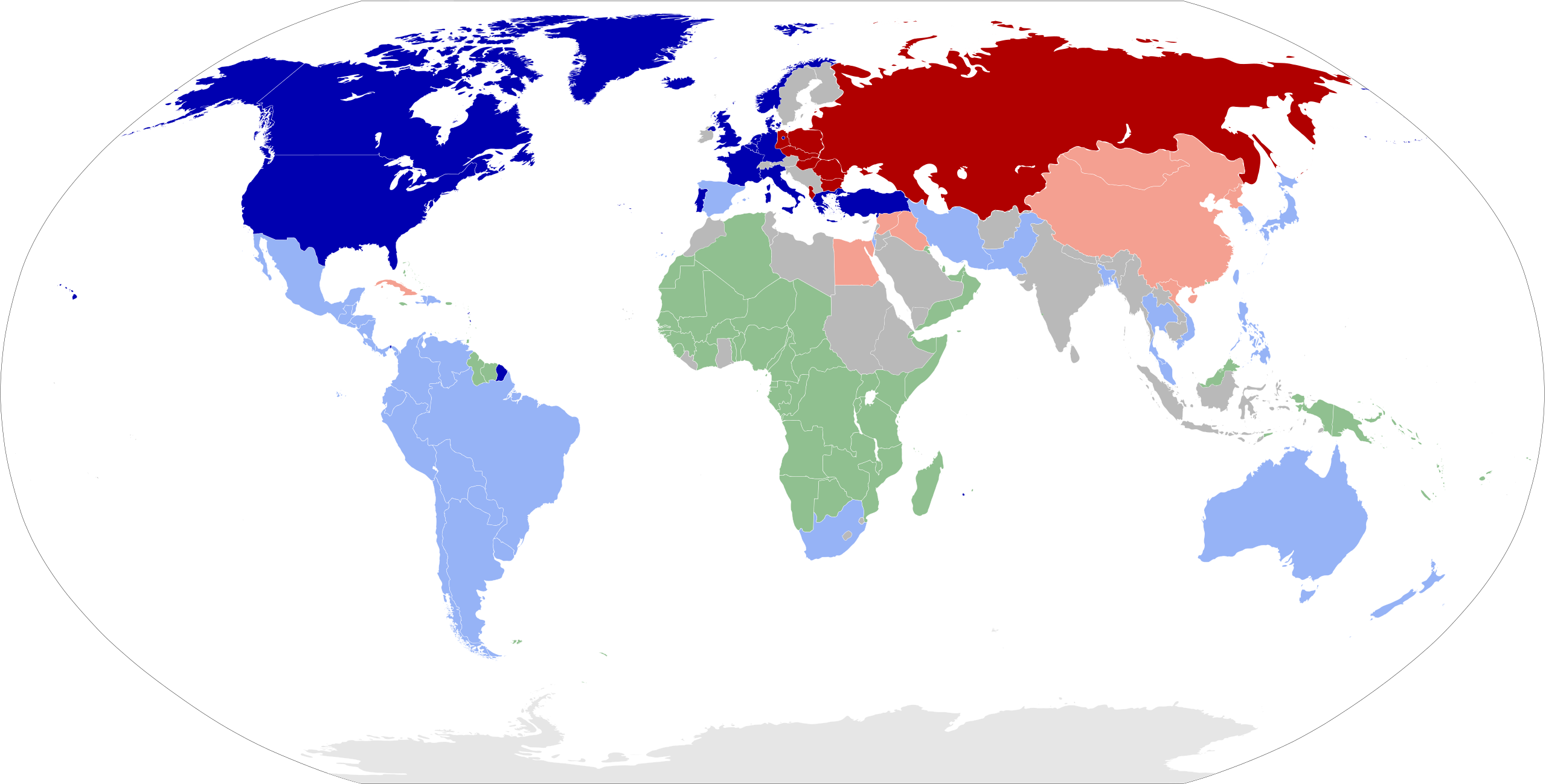
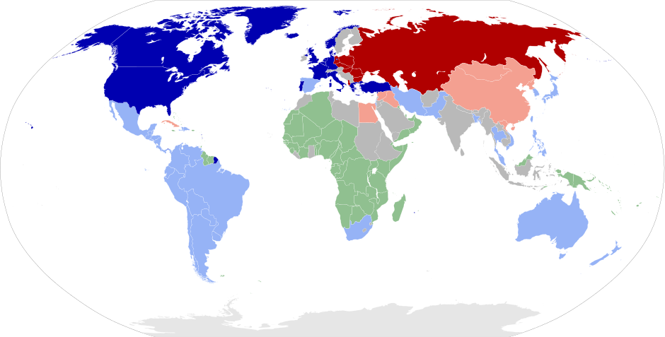
Bahasa Indonesia: Peta dunia pada masa Perang Dingin tahun 1959.
Negara anggota NATO
Sekutu AS lainnya
Negara jajahan/koloni
Negara anggota Pakta Warsawa
Sekutu Uni Soviet lainnya
Negara non-blok Čeština: členské země NATO
jiní spojenci USA
kolonie
členské země Varšavské smlouvy
jiní spojenci SSSR
neutrální země Deutsch: Die Welt 1959 zur Zeit des Kalten Kriegs.
NATO-Mitgliedstaaten
Andere Verbündete der USA
Kolonisierte Länder
Warschauer-Pakt-Staaten
Andere Verbündete der UdSSR
Blockfreie Staaten English: World map showing the two blocs during the Cold War in 1959.
NATO member states
Other allies of the USA
Colonized countries
Warsaw Pact member states
Other allies of the USSR
Non-aligned nations Español: Guerra Fria - Situación de la confrontación bipolar en 1959.
Miembros de la OTAN
Otros aliados de Estados Unidos
Países colonizados
Miembros del Pacto de Varsovia
Otros aliados de la Unión Soviética
Paises Neutrales Euskara: NATOko kideak
Estatu Batuen beste herri aliatuak
Kolonizatutako herriak
Varsoviako itunako kideak
SESBren best herri aliatuak
Herri ez lerrokatuak Français : Carte du monde montrant les deux blocs de la guerre froide en 1959.
Pays membres de l'OTAN
Autres pays alliés des États-Unis
Pays colonisés
Pays membres du pacte de Varsovie
Autres pays alliés de l’URSS
Pays non-alignés Italiano: Il mondo nel 1959, durante la Guerra Fredda.
Paesi membri della NATO
Altri paesi alleati degli USA
Paesi colonizzati
Paesi membri del Patto di Varsavia
Altri paesi alleati dell'URSS
Paesi neutrali Lietuvių: NATO valstybės narės
Kitos JAV sąjungininkės
Kolonizuotos šalys
Varšuvos pakto valstybės nares
Kitos TSRS sąjungininkės
Neprisijungusios tautos Magyar: A két nagy blokk térképen a Hidegháború alatt 1959-ben.
NATO tagállamok
Az USA egyéb szövetségesei
Gyarmatok
A Varsói Szerződés tagjai
A Szovjetúnió egyéb szövetségesei
Semleges államok Nederlands: NAVO leden
Aanhangers van de Verenigde Staten
Koloniën
Warschau-pact staten
Aanhangers van de Sovjet Unie
Neutrale staten Polski: Członkowie NATO
Inni sojusznicy USA
Państwa skolonizowane
Członkowie Układu Warszawskiego
Inni sojusznicy ZSRR
Państwa niezaangażowane Português: Mapa do mundo com os dois blocos durante a guerra fria, em 1959.
Países membros da OTAN
Outros aliados dos EUA
Colônias
Países do Pacto de Varsóvia
Outros aliados da URSS
Países neutros Română: Harta mondială în 1959, în timpul războiului rece.
Statele membre ale NATO
Alți aliați din SUA
Țările colonizate
Statele membre ale Organizației Tratatului de la Varșovia
Alți aliați din URSS
Țările nealiniate Suomi: NATO:n jäsenmaat
Muut USA:n liittolaiset
Siirtomaat
Varsovan liiton jäsenmaat
Muut Neuvostoliiton liittolaiset
Liittoutumattomat maat Tagalog: Ang mapa ng daigdig na ipinapakita ang dalawang alyansa sa Digmaang Malamig noong 1959.
Mga bansang kasapi ng NATO
Iba pang mga kaanib ng Estados Unidos
Mga sinakop na bansa
Mga kasapi ng Kasunduan sa Warsaw
Iba pang mga kaanib ng Unyong Sobyet
Mga bansang walang kaanib Tiếng Việt: Quốc gia thành viên NATO
Các đồng minh của Hoa Kỳ
Các nước thuộc địa
Khối hiệp ước Warsaw thành viên
Các đồng minh của Liên Xô
Các quốc gia không liên kết Беларуская: Карта свету ў 1959 годзе, падчас Халоднай вайны
Дзяржавы-чальцы НАТА
Іншыя саюзнікі ЗША
Каланіяльныя краіны
Дзяржавы-чальцы Варшаўскай дамовы
Іншыя саюзнікі СССР
Краіны-ўдзельнікі руху недалучэння Български: държави-членки на НАТО
други съюзници на САЩ
колонии
държави-членки на Варшавския договор
други съюзници на СССР
необвързани държави Русский: Карта мира в 1959 году, во время Холодной войны.
Государства-члены НАТО
Другие союзники США
Колонии европейских государств
Государства-члены Организации Варшавского договора
Другие союзники СССР
Неприсоединившиеся страны Українська: Держави-члени НАТО
Інші союзники США
Колоніальні країни
Варшавського Договору держав-членів
Інші союзники СРСР
Неприєднані країни ไทย: ประเทศสมาชิกองค์การสนธิสัญญาป้องกันแอตแลนติกเหนือ
ประเทศพันธมิตรของสหรัฐอเมริกา
ประเทศอาณานิคม
ประเทศสมาชิกสนธิสัญญาวอร์ซอ
ประเทศพันธมิตรของสหภาพสาธารณรัฐสังคมนิยมโซเวียต
ประเทศที่ไม่เกี่ยวข้อง 한국어: 1959년 세계지도, 냉전의 두 축.
북대서양 조약 기구의 회원
미국의 다른 동맹국
식민지 지역
바르샤바 조약 기구 회원국
소련의 기타 동맹국
중립국 日本語: NATO加盟国
アメリカの他の同盟国
植民地の国
ワルシャワ条約機構加盟国
ソ連の他の同盟国
非同盟諸国 中文: 1959年两极格局下的世界地图。
北大西洋公约成员国
美国的其它盟国
殖民地区域
华沙条约组织成员国
苏联的其它盟国
不结盟的国家 العربية : خريطة العالم في فترة الحرب الباردة سنة 1959en:الحرب الباردة.
دول حلف الناتو
الدول المتحالفة مع الولايات المتحدة
الدول تحت الإستعمار الأجنبي
دول حلف وارسو
الدول المتحالفة مع الإتحاد السوفيتي
دول لا تنتمي للمعسكر الأمريكي والسوفيتي فارسی : نقشه جهانی که دو بلوک را در جریان جنگ سرد در سال 1959 نشان می دهد.
کشور های عضو ناتو
دیگر متحدان ایالات متحده آمریکا
کشور های مستعمره
کشور های عضو پیمان ورشو
دیگر متحدان اتحاد جماهیر شوروی
کشور های غیر متعهد |
| Data | |
| Fonte |
Own work, from :
|
| Autor | Sémhur |
| SVG desarrollo | El código fuente de esta imagen SVG es válido. Este mapa fue creado con Inkscape. |
Llicencia
Yo, el titular de los drechos d'autor d'esta obra, la espublizo baxo les siguientes llicencies:

|
Autorízase la copia, distribución y/o cambéu d'esti documentu baxo los términos de la Llicencia de documentación llibre GNU, versión 1.2 o cualesquier otra que nel futuru espublice la Free Software Foundation; ensin seiciones invariables, testos de portada, nin testos de contraportada. S'inclúi una copia de la llicencia na seición titulada GNU Free Documentation License. |
This file is licensed under the Creative Commons Attribution-Share Alike 4.0 International, 3.0 Unported, 2.5 Generic, 2.0 Generic and 1.0 Generic license.
- Ye llibre:
- pa compartir – pa copiar, distribuir y comunicar públicamente la obra
- pa remezclar – p'adautar la obra
- Baxo les condiciones siguientes:
- reconocimientu – Tienes de dar el créitu apropiáu, apurrir un enllaz a la llicencia ya indicar si realizasti dalgún cambéu. Puedes faelo de cualquier mou razonable ,pero non de manera que suxera l'encontu del autor pa ti o pal usu que faigas.
- compartir igual – Si entemeces, tresformes o te bases nesti material, tienes de distribuir les tos contribuciones baxo la mesma llicencia o una compatible cola orixinal.
Pues seleicionar la llicencia que prefieras.
Related images
- File:Cold War Map 1980.svg - 1980 Cold War map
| Maps of world history | |
| BC | |
|
| |
| AD |
1 · 50 · 100 · 200 · 250 · 300 · 400 · 500 · 700 · 750 · 820 · 900 · 1200 · 1500 · 1556 · 1648 · 1700 · 1750 · 1815 · 1859 · 1871 · 1914 · 1935 · 1954 · 1989 · 2000 · |
|
Maps of colonization history | |
|
see also: Eastern Hemisphere only maps template (1300BC-1500AD) | |
| (this template: · view · discuss ) | |
.jpg)
._LOC_2001620596.jpg)
Historial del ficheru
Calca nuna fecha/hora pa ver el ficheru como taba daquella.
| Data/Hora | Miniatura | Dimensiones | Usuariu | Comentariu | |
|---|---|---|---|---|---|
| actual | 13:09 19 abr 2017 | | 940 × 477 (853 kB) | Sémhur | Valid SVG |
| 18:24 14 abr 2017 |  | 940 × 477 (853 kB) | Monsieur Patillo | Pays colonisé | |
| 20:50 3 pay 2015 |  | 940 × 477 (854 kB) | SenseiAC | whatever you say, it was anyway legally the case (and at this title, Algeria was fully part of the EEC eg) | |
| 03:59 26 xnt 2011 |  | 940 × 477 (813 kB) | ArséniureDeGallium | retour à la version de Sémhur | |
| 06:12 24 xnt 2011 |  | 940 × 477 (854 kB) | Hoshie | fixed Fr. Guiana Algeria - it was an Overseas Department of France in 1959; see File talk:Cold War Map 1959.png. | |
| 13:34 2 pay 2010 |  | 940 × 477 (854 kB) | Sémhur | Namibia in green, as a colony of South Africa ; North Yemen in gray. | |
| 16:51 15 abr 2008 |  | 940 × 477 (854 kB) | Sémhur | South Africa in light blue | |
| 18:06 14 abr 2008 |  | 940 × 477 (854 kB) | Sémhur | Correcting one blue color | |
| 17:35 14 abr 2008 |  | 940 × 477 (853 kB) | Sémhur | {{Information |Description= {{en|World map showing the two blocs during the cold war in 1959.}} {{fr|Carte du monde montrant les deux blocs de la guerre froide en 1959.]] |Source=Own work, from : * [[:Image:BlankMap- |
Usu del ficheru
Nun hai páxines qu'usen esti ficheru.